
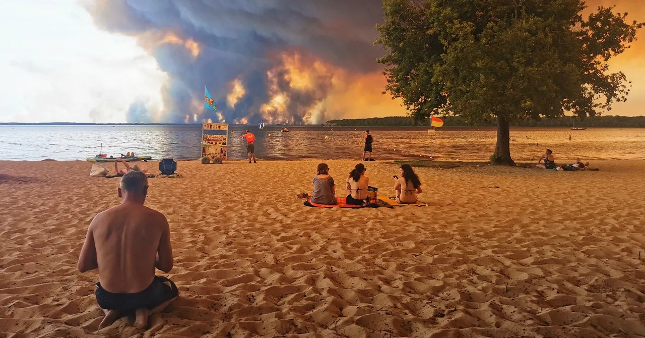
The skies over France have changed. Not just because of smoke. Because of something new. Something terrifyingly powerful. Firefighters there are watching a phenomenon that has never been recorded in the country’s history. Pyrocumulonimbus clouds. They are towering pillars of smoke and ice generated by the sheer ferocity of the blazes.
It’s a sign that the fire weather here is no longer just about hot air. It’s about the atmosphere itself turning against the people on the ground.
What is a Pyrocumulonimbus Cloud?
You might wonder how fire makes its own weather. It’s basic physics, brutalized by scale. You need heat. France has that. The fires are burning with an intensity that defies explanation. But heat alone isn’t enough.
You also need the right atmospheric setup. Dry conditions near the ground. Moisture higher up. As the superheated smoke from a wildfire shoots miles into the sky, it hits that cooler air. The water vapor in the smoke condenses around ash particles. It turns into droplets. Then ice crystals. And then—boom—you have a cloud.
A pyrocumulonimbus.
This isn’t a gentle rain cloud. It’s a monster. It doesn’t bring relief. It brings lightning. Lightning that starts more fires. It brings downdrafts—powerful gusts of wind hitting the ground and fanning the flames like a bellows. In the worst cases, they can even spawn tornadoes.
A Record-Shattering Summer
Until this week, no one in France had documented this. Meteorologists knew it happened in the US. Canada. Australia. Places where wildfires are part of the landscape. But France? Not so much. Not at this scale.
Last week was the worst for wildfires in two decades. The data from the European Forest Fire Information System confirms it. It was worse than any previous week by a huge margin. Satellite data backs it up. More than 220,cl000 acres have burned. That’s six times the annual average. Six.
The numbers are staggering. And they tell a story that’s impossible to ignore. This isn’t a bad season. It’s an extreme one.
Why Climate Change Makes This Happen
Why are the odds stacked against firefighters now? Why do we see pyrocumulonimbus clouds where they didn’t exist before?
The answer lies in the air we breathe. And what we put into it. Burning fossil fuels heats the planet. It dries out the land. It makes wildfires more common. More destructive. A 2024 global study showed that extreme fire events more than doubled between 2003 and 2023. Six of those extreme years happened in just the last eight.
We are living in a world where “record-smashing” is the new normal.
Firefighters describe the situation as an “operational impossibility.” That’s a polite way of saying: this is a natural force beyond our control. When the sky creates its own wind, when the smoke becomes a storm system, you can’t just hose it down.
What Comes Next
For a brief moment over the weekend, temperatures dipped. The wind shifted. There was a breath of relief. It was slight. Temporary.
By later this week, the mercury is expected to rocket back up. Above 104°F (40°C) in France. 108°F in neighboring Spain. The conditions are perfect for more pyrocumulonimbus formation. Perfect for the fire clouds.
So firefighters are gearing up again. Facing the same invisible enemy. A sky that fights back.
It raises a question that hangs heavy over the continent. If the weather itself is becoming the enemy, where do we draw the line between fighting fire and fighting the climate?
No easy answers. Just heat. And smoke. And the long, uncertain wait for rain that may not come.